GALLERIES > BIRDS > CHARADRIIFORMES > SCOLOPACIDAE > SPOTTED SANDPIPER [Actitis macularius] [plot on map]
|
|
Location: Lake Cochise - Willcox, AZGPS: 32.2N, -109.8W, elev=4,155' MAP Date: April 29, 2023 ID : B13K2752 [4896 x 3264]
|
|

|
Location: Galileo Hills, CAGPS: 35.2N, -117.8W, elev=2,953' MAP Date: May 9, 2009 ID : 7C2V7299 [3888 x 2592]
|
Location: Playa del Rey (Ballona Creek), CAGPS: 34.0N, -118.4W, elev=0' MAP Date: September 17, 2007 ID : 1428 [3888 x 2592]
|
|
Location: Lake Cochise - Willcox, AZGPS: 32.2N, -109.8W, elev=4,155' MAP Date: April 29, 2023 ID : B13K2743 [4896 x 3264]
|
|
|
Location: Estero San Jose, San Jose del Cabo, MexicoGPS: 23.1N, -109.7W, elev=26' MAP Date: February 1, 2013 ID : B13K2087 [4896 x 3264]
|
|
|
Location: Playa del Rey (Ballona Creek), CAGPS: 34.0N, -118.4W, elev=0' MAP Date: April 9, 2016 ID : B13K1451 [4896 x 3264]
|
|
|
Location: Playa del Rey (Ballona Creek), CAGPS: 34.0N, -118.4W, elev=0' MAP Date: April 9, 2016 ID : B13K1434 [4896 x 3264]
|
|
|
Location: Playa del Rey (Ballona Creek), CAGPS: 34.0N, -118.4W, elev=0' MAP Date: August 24, 2010 ID : 7C2V2268 [3888 x 2592]
|
|
|
Location: Andros Island, BahamasGPS: 24.9N, -77.9W, elev=32' MAP Date: September 26, 2011 ID : B13K9060 [4896 x 3264]
|
|
|
Location: Salton Sea - Unit 1, CAGPS: 33.1N, -115.7W, elev=-212' MAP Date: November 10, 2010 ID : B13K4423 [4896 x 3264]
|
|
|
Location: Playa del Rey (Del Rey Lagoon), CAGPS: 34.0N, -118.5W, elev=3' MAP Date: January 3, 2016 ID : B13K0066 [4896 x 3264]
|
|
|
Location: Galileo Hills, CAGPS: 35.2N, -117.8W, elev=2,953' MAP Date: May 9, 2009 ID : 7C2V7300 [3888 x 2592]
|
Location: St. Lucia, Lesser AntillesGPS: 13.8N, -61.0W, elev=835' MAP Date: October 22, 2009 ID : 7C2V4321 [3888 x 2592]
|
|
Location: Playa del Rey (Ballona Creek), CAGPS: 34.0N, -118.4W, elev=0' MAP Date: September 17, 2007 ID : 1222 [3888 x 2592]
|
Location: Playa del Rey (Ballona Creek), CAGPS: 34.0N, -118.4W, elev=0' MAP Date: September 17, 2007 ID : 1326 [3888 x 2592]
|
|
Location: Playa del Rey (Ballona Creek), CAGPS: 34.0N, -118.4W, elev=0' MAP Date: September 17, 2007 ID : 1342 [3888 x 2592]
|
Location: Playa del Rey (Ballona Creek), CAGPS: 34.0N, -118.4W, elev=0' MAP Date: December 28, 2007 ID : 0274 [3888 x 2592]
|
|
Location: Playa del Rey (Ballona Creek), CAGPS: 34.0N, -118.4W, elev=0' MAP Date: September 17, 2007 ID : 1247 [3888 x 2592]
|
|
SPECIES INFO
The Spotted Sandpiper (Actitis macularia) is a small shorebird, 18-20 cm long. Together with its sister species, the Common Sandpiper (A. hypoleucos) they make up the genus Actitis. They replace each other geographically; stray birds may settle down with breeders of the other species and hybridize.
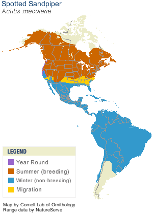
Their breeding habitat is near fresh water across most of Canada and the United States. They migrate to the southern United States and South America, and are very rare vagrants to western Europe. These are not gregarious birds and are seldom seen in flocks.
Adults have short yellowish legs and an orange bill with a dark tip. The body is brown on top and white underneath with black spots. Non-breeding birds, depicted below, do not have the spotted underparts, and are very similar to the Common Sandpiper of Eurasia; the main difference is the more washed-out wing pattern visible in flight and the normally light yellow legs and feet of the Spotted Sandpiper. The Acititis species have a distinctive stiff-winged flight low over the water.
Spotted Sandpipers nest on the ground. Females may mate with more than one male, leaving incubation to them.
These birds forage on ground or water, picking up food by sight. They may also catch insects in flight. They eat insects, crustaceans and other invertebrates. As they forage, they can be recognized by their constant nodding and teetering.
|
|


