GALLERIES > BIRDS > CHARADRIIFORMES > RECURVIROSTRIDAE > AMERICAN AVOCET [Recurvirostra americana] [plot on map]
Location: Lake Cochise - Willcox, AZGPS: 32.2N, -109.8W, elev=4,155' MAP Date: April 29, 2023 ID : B13K2687 [4896 x 3264]
|
|

|
Location: San Jacinto Wildlife Area, CAGPS: 33.9N, -117.1W, elev=1,426' MAP Date: April 8, 2023 ID : B13K2600 [4896 x 3264]
|
|
|
Location: Lake Cochise - Willcox, AZGPS: 32.2N, -109.8W, elev=4,155' MAP Date: April 29, 2023 ID : B13K2679 [4896 x 3264]
|
|
|
Location: Sepulveda Basin, CAGPS: 34.2N, -118.5W, elev=689' MAP Date: May 28, 2016 ID : B13K1553 [4896 x 3264]
|
|
|
Location: San Jacinto Wildlife Area, CAGPS: 33.9N, -117.1W, elev=1,426' MAP Date: September 15, 2013 ID : B13K4372 [4896 x 3264]
|
|
|
Location: San Jacinto Wildlife Area, CAGPS: 33.9N, -117.1W, elev=1,426' MAP Date: October 15, 2011 ID : B13K9265 [4896 x 3264]
|
|
|
Location: San Jacinto Wildlife Area, CAGPS: 33.9N, -117.1W, elev=1,426' MAP Date: August 22, 2010 ID : 7C2V2069 [3888 x 2592]
|
|
|
Location: San Jacinto Wildlife Area, CAGPS: 33.9N, -117.1W, elev=1,426' MAP Date: August 22, 2010 ID : 7C2V2072 [3888 x 2592]
|
|
|
Location: Salton Sea - Unit 1, CAGPS: 33.1N, -115.7W, elev=-212' MAP Date: November 10, 2010 ID : B13K4347 [4896 x 3264]
|
|
|
Location: Salton Sea, CAGPS: 33.1N, -115.7W, elev=0' MAP Date: August 15, 2009 ID : 7C2V1562 [3888 x 2592]
|
Location: Salton Sea, CAGPS: 33.1N, -115.7W, elev=0' MAP Date: August 15, 2009 ID : 7C2V1555 [3888 x 2592]
|
|
Location: Playa del Rey (Del Rey Lagoon), CAGPS: 34.0N, -118.5W, elev=3' MAP Date: April 1, 2008 ID : 7050 [3888 x 2592]
|
Location: Jekyll Island, GAGPS: 31.1N, -81.4W, elev=7' MAP Date: February 10, 2008 ID : 3694 [3888 x 2592]
|
|
Location: Salton Sea, CAGPS: 33.2N, -115.6W, elev=-232' MAP Date: November 20, 2006 ID : ? [3888 x 2592]
|
Location: Lancaster Sewage Ponds, CAGPS: 34.8N, -118.2W, elev=2,314' MAP Date: August 2, 2008 ID : 7C2V6470 [3888 x 2592]
|
|
Location: Lancaster Sewage Ponds, CAGPS: 34.8N, -118.2W, elev=2,314' MAP Date: August 2, 2008 ID : 7C2V6480 [3888 x 2592]
|
Location: Lancaster Sewage Ponds, CAGPS: 34.8N, -118.2W, elev=2,314' MAP Date: August 2, 2008 ID : 7C2V6484 [3888 x 2592]
|
|
Location: Lancaster Sewage Ponds, CAGPS: 34.8N, -118.2W, elev=2,314' MAP Date: August 2, 2008 ID : 7C2V6489 [3888 x 2592]
|
Location: Lancaster Sewage Ponds, CAGPS: 34.8N, -118.2W, elev=2,314' MAP Date: August 2, 2008 ID : 7C2V6497 [3888 x 2592]
|
|
Location: Lancaster Sewage Ponds, CAGPS: 34.8N, -118.2W, elev=2,314' MAP Date: August 2, 2008 ID : 7C2V6510 [3888 x 2592]
|
|
SPECIES INFO
The American Avocet (Recurvirostra americana) is a large wader in the avocet and stilt family, Recurvirostridae.
This avocet has long, thin, gray legs, giving it its colloquial name, "blue shanks". The plumage is black and white on the back with white on the underbelly. The neck and head are cinnamon colored in the summer and gray in the winter. The long, thin bill is upturned at the end. The adult is about 45 cm (18 inches) tall.
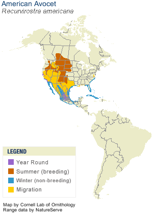
The breeding habitat is marshes, beaches, prairie ponds, and shallow lakes in the mid-west and on the Pacific coast of North America. The American Avocet nests on open ground, often in small groups, sometimes with other waders. A pair will rear one brood per season, with both male and female providing parental care for the young.
This species is migratory, and mostly winters on the southern Atlantic and Pacific coasts of Mexico and the United States.
The American Avocet forages in shallow water or on mud flats, often sweeping its bill from side to side in water as it seeks its crustacean and insect prey.
The American Avocet (Recurvirostra americana) is protected under the Migratory Bird Treaty Act of 1918.
|
|


